Hill Figures
Hill figures are exactly that – a large figure cut into the side of a hill. They are mostly animals or people, but other objects like crowns and religious crosses can be seen across the UK.

A horse cut into the side of a hill
Hill figures can be useful landmarks for navigation, particularly in areas that are lacking in other distinct visual features. They’re marked on the chart with a symbol of what the hill figure is and its orientation:

Instrument Approach Feathers
Instrument approach feathers are marked where aerodromes have an instrument approach procedure outside controlled airspace.
The chart below shows Gloucester airport with two instrument approach feathers. This means there could be aircraft following the instrument approach to this runway – likely flying a long final approach – both inside cloud and out of it.
The air traffic controllers may not necessarily have a radar screen to help keep aircraft separated, so you are strongly recommended to contact the aerodrome Air Traffic Service Unit (ATSU) if you plan to fly within 10nm of an aerodrome with instrument approach feathers.

Gas Venting Sites
Gas Venting Sites (GVS) are used to release the natural gasses that are produced by mining sites. These gases can be contained at extremely high pressure and be released at very high speeds.
Flying over a GVS while venting is in progress can cause severe turbulence and surging of turbine engines up to the altitude marked on the chart.
Severe turbulence means you should plan to fly around them!

A gas venting site that extends up to 3,600ft AMSL
High Intensity Radio Transmission Areas (HIRTA)
A High Intensity Radio Transmission Area (HIRTA) is exactly what it sounds like – an area in which there may be high intensity radio energy that can cause problems for pilots.
If you fly through these areas, you may experience interference or possibly damage to your communication and navigation radios. Not much other information is published about these areas so we suggest you keep clear.
HIRTAs are marked on the chart by a red circle with cross hatching through the circle.

The Fylingdales HIRTA, marked as extending up to 40,000ft (Fylingdales/40.0)
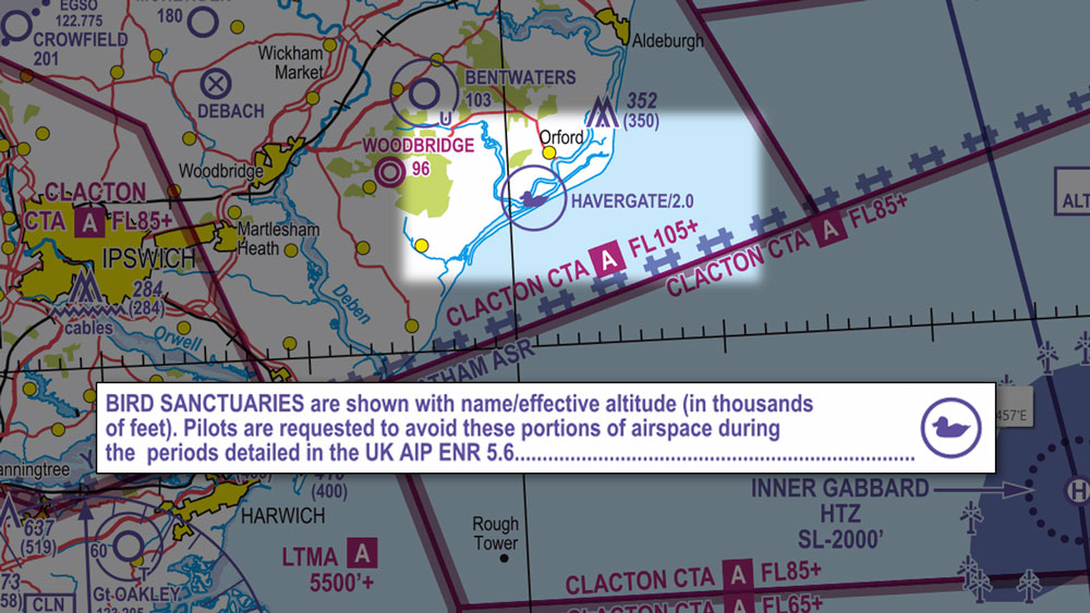
Bird Sanctuaries
Bird sanctuaries marked on the chart are areas in which large colonies of birds are known to breed. Pilots are specifically requested to avoid bird sanctuaries, especially during any stated breeding seasons.
TMZs and RMZs
Transponder Mandatory Zones (TMZs) are areas in which it is mandatory to have a functioning transponder that is transmitting both your position and altitude before entering.
TMZs are marked on the chart by brown half-circles.

Radio Mandatory Zones (RMZs) are areas in which it is mandatory to establish radio contact with the relevant Air Traffic Service Unit (ATSU) before entering.
RMZs are marked on the chart by blue half-circles.
